Trudi Lloyd Williams: The World's Oldest Boatyard

Trudi Lloyd Williams: The World's Oldest Boatyard

Environmental artist Trudi Lloyd Williams looks back on how the Solent was formed and explores how people have responded to climate issues through art and architecture.

When you look at the Solent on a calm day it is very hard to imagine that the Isle of Wight - and in fact England, Wales and Scotland - became an island due to one cataclysmic event in around 6100 BC. Roughly 70 miles off the coast of Norway, a 200-mile stretch of seabed shelf slipped deeper into the North Sea, creating a cavernous void. Sea water from every direction surged into it, before returning in an equal and opposite surge; a huge tsunami.

After seeing the sea sucked away, as if by a massive low tide, the British Isles were now in the path of an enormous wave. It became the most powerful natural disaster in the Western world in 8,000 years. The giant wave destroyed everything in its path and reached 50 miles inland, the higher waters submerging the land connections between Great Britain, the Isle of Wight, and Continental Europe. What had at one time been a river and marshland where settlers went about their business was no more: two new islands and the Solent had been created.

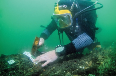
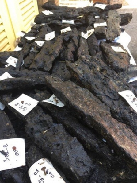
The waters of the Solent have kept the secrets of this lost land for thousands of years. Recently a team of divers at Bouldnor Cliff thought they had uncovered the remains of a forest, but soon realised the timbers were something else altogether: the oldest boat building yard in the world. Although about 40 ft deep, the site is in danger of being lost due to the area's strong currents, and this led archaeologist Gary Momber to excavate the site. Historian Neil Oliver even recorded the moment when, as a novice diver, he came face-to-face with the oldest boatyard in the world. Artefacts have been so well preserved by the anaerobic sediment that even the possible remains of rope have been retrieved!

The tsunami that created our islands may have happened millennia ago, but even before it occurred increasing global temperatures had been causing very wet weather and continually rising sea levels. Does that sound familiar? I am not predicting a tidal wave, but with increasingly frequent extreme weather events in our own time, and under similar circumstances, it does strike a chord!

Whilst doing my MA in Design for the Environment at Chelsea College of Art I was introduced to environmental artists Helen Mayer Harrison and Newton Harrison. I was very fortunate to participate in their project Greenhouse Britain 2007-2009. Part of the work included a huge 3D map of Britain with projections of incremental sea level rise and the subsequent loss of land, particularly in the South East and South West where massive displacements of the population would occur. I remember it took my breath away, and I often still recall its visual power in communicating a difficult message.

Since my graduation in 2003, I too have been raising awareness about issues affecting water, whether that be inland man-made waterways or coastal waters. The issues are often complex and sometimes unpalatable, but when they are communicated visually I find that spectators, participants and viewers are often more receptive. They go on their own personal journey as they consider the aesthetics, inferences, and connections of the art - everyone has their own take. My preference is to nudge them along this journey, giving prompts, clues, and links that are supported by knowledge and evidence from project partners; there is plenty of information available for the curious.

Whilst living and working in the Ionian Islands in Greece last year, I had first-hand experience on no fewer than five occasions of how the nearby Eurasian, Anatolian and Aegean tectonic plates jostle for position. One night I was abruptly woken from a sound sleep at 4:05 AM by the bed shaking and the ceiling creaking. Earthquake! I was wide awake, adrenaline pumping, and dashed outside clutching my dog. The earthquake subsided pretty quickly, but the epicentre had been only about 60 miles North at Preveza.

The islands are littered with reminders of the Earth’s volatility: cracks in the roads, rocks strewn everywhere, and in some cases abandoned villages filled with precarious and partially collapsed buildings. In the 1800s, during the British occupation of Lefkada, the inhabitants created new architectural regulations to prevent the loss of life in earthquakes. No new buildings were to be constructed of stone above the ground floor, but rather of robust timber frameworks that would collapse outwards instead of inwards onto their occupants. These wooden structures were then clad in corrugated iron panels, trimmed with architectural details, and painted in the most exotic colours reminiscent of Cuba, giving Lefkas its unique character.

Anti-seismic architecture in Lefkas, Greece © Trudi Lloyd Williams

Anti-seismic architecture in Lefkas, Greece © Trudi Lloyd Williams

Man has become adept at finding, creating, and inventing solutions to the problems that mother nature cares to throw at us. When it comes to climate change and plastic marine pollution there are already many ingenious devices available, like the Seabin recently installed at Ocean Village Marina. I wonder how much the Solent will change in the years to come; centuries from now, will our inventions be revealed by a changing climate or a cataclysmic event?

Spiny Seahorses and Ripping Yarns

Trudi is collaborating with us on an element of our marine project Secrets of the Solent. Together, we're working with local communities to collect plastic marine litter marine and transform it into an inspirational sculpture.

Learn more about our collaboration