This Land of Ours

This Land of Ours

In 1949, an imperfect mapping process removed thousands of footpaths, byways, and bridleways from public use. Hear from guest blogger Paul Howland about his mission to restore Hampshire's 'lost ways'.

Many years ago, there was a small boy who lived with his sister and parents in the Chiltern Hills. He grew up thinking of the countryside as his playground, but as he grew older it began to change around him. Signs saying ‘PRIVATE’ and ‘KEEP OUT’ appeared in the woods where he played, and with them came a very real sadness.

This childhood feeling of exclusion left me, the boy in question, with strong convictions about access to the countryside. As an adult, this access has become tightly bound to my sense of citizenship and belonging. I know the joy and healing it offers, and want everyone to be able to benefit as I have. Something, as they say, had to be done.

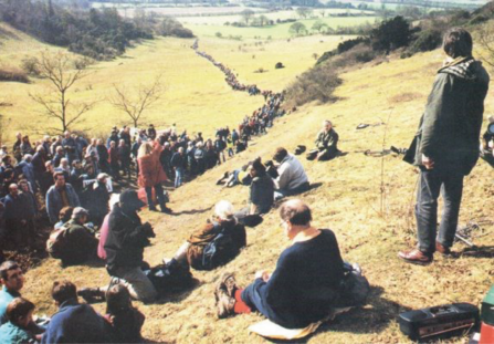
Ramblers on Shirburn Hill listen to Gordon Prentice © Andrew Bennett

Ramblers rally on Shirburn Hill to listen to Gordon Prentice (standing, right) © Andrew Bennett

In the 1990s I joined the Ramblers Association and started working on their campaign to improve access to our countryside. In 1999 we pushed the Government to do just that: after much lobbying and a huge demonstration on the Chiltern Escarpment, the Countryside and Rights of Way Act was finally passed in 2000.

The CROW Act, as it became known, established the right to roam on mountain, moor, heath, down and registered common land, with a provision to extend this to woodland and riverside if the Government saw fit. But it also introduced a new challenge: a time limit on the recovery of lost rights of way using historic evidence.

In 1949, an Act of Parliament instructed County Councils to record public rights of way through the creation of the definitive maps. Unfortunately, for a variety of reasons, many routes were ‘lost’ during this process - we estimate at least 600 routes in Hampshire alone; the equivalent of around 300 miles of footpaths, byways, or bridleways!

With the passing of the CROW Act, anyone wishing to recover these ‘lost ways’ had until 2026 to do so. Of course, in an ideal world, this wouldn’t be necessary, but I couldn’t let these important access routes be lost forever. So began my journey of discovery about this land and our ever-changing place within it.

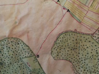
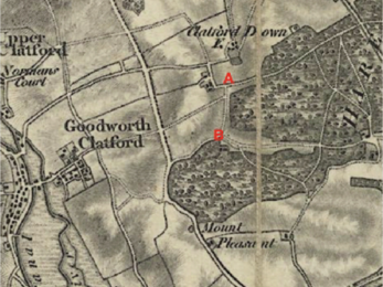
I often start my searches with the fantastic Old Hampshire Mapped, which has traveller’s maps from the 14th Century to 1930, or historic Ordnance Survey maps made available by the National Library of Scotland. These sources are useful for finding the locations of old routes, but lack the legal authority needed for a recovery application.

More legally robust are tithe maps, which indicate parish boundaries and land ownership – I often access them at the Hampshire Archives, or at a cost via The Geneaologist. Enclosure maps, which include similar information and are also available at the Hampshire Archives, can be very helpful too.

I consult various other sources, such as such as manorial maps, sales maps and Railway Deposit maps, but perhaps the most useful are the Finance Act maps of 1910 (available from the National Archives) and the Highway Handover maps of 1929 (available from the Hampshire Archives). These are my main sources for most of my investigations.

The 1910 Finance Maps resulted from an attempt to identify taxable land – public highways were owned by highway authorities, and therefore marked as tax-exempt areas. The 1929 maps were produced when Rural District Councils handed over responsibility for rights of way to the County Council, providing robust evidence of their status at the time.

Once I have gathered all the evidence available, I put together an application to recover the lost right of way, which I submit to Hampshire County Council. If they are convinced, they will eventually add the route to their definitive map, thereby reviving its status as a place for all members of the public to use and enjoy.

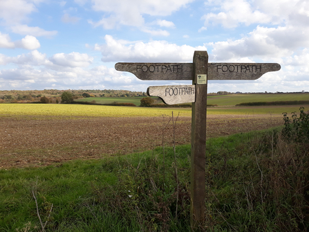
Footpath near Nately in Hampshire © Simon Burchell

Footpath near Nately in Hampshire © Simon Burchell

The process of re-discovering these lost ways has brought with it unexpected delights. Looking at maps through the ages shows how the countryside has changed over time. Tithe maps, for example, tell us about the lives of the owners and occupiers: poor widows making a living by foraging hedgerows, or aristocratic owners taking rent from vast swathes of land. It’s a veritable treasure trove of social history.

Inspecting these ancient routes on the ground also brings me a new understanding of this land of ours. You can still walk sunken tracks that were dug out in the 1800s so that heavily laden horse-drawn wagons could get their produce to market. You can see still unusually wide hedges, which were once a pair embracing a road that has since been abandoned.

Furthermore, these investigations are beginning to show why public rights of way were lost in the first place. Some were closed for military activity during the World Wars, but never recovered when the land was returned to civilian use. Others fell victim to the influence of historic landowners who viewed them as intrusive or inconvenient to their properties.

While many of these could potentially be restored, others may sadly be beyond rescue. The march of time has brought new roads and housing developments, causing public paths to be legally closed or diverted. The loss of footpaths, byways, and bridleways is still occurring today, making the recovery of old routes all the more crucial.

To date, I have made applications for over 160 ‘lost ways’ and hope to discover many more. People all over the country are undertaking this urgent work, but we need help to recover as many routes as possible before the deadline. If you would like to get involved, please contact the Ramblers or the British Horse Society.