World Wetlands Day 2024

World Wetlands Day 2024

From the tiniest of garden ponds to whole river systems complete with wet floodplains, our wetlands are one of the most biodiverse habitats in the UK.

From the tiniest garden ponds to whole river systems, complete with wet floodplains, our wetlands are one of the most biodiverse habitats in the UK. Yet, with 75% of the UK’s wetlands lost in the last 300 years, they are disappearing three times faster than forests! Despite government targets of achieving 100% healthy waters by 2027, a staggering 86% of rivers in the UK don’t meet good ecological status. This is due to numerous factors, including:

  • Sewage discharge
  • Farming impacts (e.g. fertilisers, pesticides and soil run-off)
  • Chemicals from industrial sources
  • Road run-off

Additionally, our rivers and their wetlands have, over time, been artificially drained, straightened, and deepened, usually to reclaim land and facilitate drainage.

However, biodiverse natural rivers and their floodplains provide wider benefits to us that we are becoming increasingly aware of and knowledgeable about. For example, floodplain wetlands such as peat bogs and fens protect against climate change by absorbing and storing carbon. Natural river processes can also help mitigate severe flooding, alleviate drought, and reduce pollution.

Cycle track, green nettles on river bank and brown river

Eastern Yar river artificially straightened next to former railway © Nicola Wheeler

River restoration projects aim to recreate these processes and restore good ecological status, provided riparian landowners can offer the space and willingness to do so. Projects typically involve reclaiming floodplain land to make room for rivers to re-meander, store floodwater, and recreate biodiverse wetland wildlife corridors. As part of the Living Landscapes initiative in 2012, the Trust and its generous members and supporters began a lengthy process to realise this vision on the Isle of Wight, with the purchase of Sandown Meadows (funded in part by a generous gift in Will) - a 17ha area of floodplain on the Eastern Yar river. Further adjacent areas of floodplain have been purchased since, so that 300ha are now being restored.

This extensive land within the lower catchment is characterised by reed beds, floodplain meadows, and coastal grazing marshes. At the downstream end, the river is deep with a very low gradient. Naturally, the river would regularly overflow its banks, depositing sediment transported by the river from higher reaches onto the floodplain. However, the river banks are artificially raised by decades of river dredgings deposited onto them, delaying the time it takes for floodwater to spread onto its floodplain. Instead, river water seeks the lowest point (often a road) and floods there first. The Trust is therefore planning to remove sections of these high banks to allow the river to better naturally connect to its floodplain and reduce flood risk. Shallow waters on the floodplain nature reserves provide rich feeding grounds for wetland wildfowl and wading birds such as snipe. Reedbeds and floodplain ditches are kept wetter for longer, ensuring they retain habitat for wetland wildlife such as water voles, Cetti’s, and reed warblers.

Drone footage of river and floodplain.

Raised dredgings bank along the Eastern Yar river

At Newchurch Moors Nature Reserve, the gradient is slightly steeper, and the river is shallower in the summer and naturally more meandering. Some sections have historically been straightened to align them with the former railway. The river straightening, both here and upstream, conveys floodwaters much faster than would naturally occur, leading to rapid erosion of the banks and riverbed. Heavier rainfall resulting from climate change and increased urbanisation exacerbates this problem. Conversely, in the drier summer months, water drains off the land too quickly, and drought becomes a major issue. By re-meandering the straightened sections of the river and reconnecting the river and floodplain, floodwater can be slowed and stored.

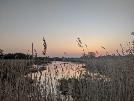
Morton Marsh - image over looking the Marsh through the reedbeds at sunset

Morton Marsh, Isle of Wight © Joe Rackstraw

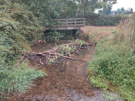
There is, of course, another way to unlock the full potential of our natural river processes to provide us with flood protection, drought alleviation, cleaner water, and biodiversity, and this is to reintroduce nature’s water engineers – beavers! By building leaky dams in shallow water, typically in the upper to mid-reaches of a river, they create a series of ponds approximately one meter deep. These ponds store water during droughts, filter out sediment and pollutants, and over time, water erodes around the edges of the dams, recreating and invigorating meanders that help to slow the flow during floods.

Beaver dams naturally reconnect the river to its floodplain, encouraging floodwater to spread out throughout the whole floodplain and not just those areas at the lower end of the catchment. This includes parts of the floodplain where there are historic lowland peat sites, which, if rewetted, would become carbon sinks instead of carbon sources. Natural wetlands are dynamic systems shaped through disturbance from floods and water flows, and by digging mini-canals, dam building, coppicing, and browsing, beavers maintain ecosystem complexity vital for most wetland species.

Beaver dam in river made up of branches and bits of trees. Walkway bridge and trees in background.

Beaver dam on the river Tale in Devon © Nicola Wheeler

Beavers feel safe in or close to water. In Germany, 95% of their impacts occurred within just 20m of the riverbank. Surely it is time to make space for these incredible water engineers who can restore our amazing wetlands ensuring our water resources are resilient and our biodiversity thrives. 

River next to green field with buffer

Habitat buffer, Bathingbourne

Drone arial shot of landscape - green fields, river, pond, and trees all within image shot

Making Wild Space for beavers along our watercourses © Dr Alan Puttock